
Least Tern Research Update using FOMNRR Sponsored Motus Receivers
The Motus Network
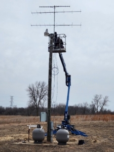
Fig. 1. Installation of a Motus station for automated radio telemetry.
FOMNRR has provided financial support for a project to build out the Motus Network in southeastern South Dakota along the MNRR.
The Motus Network is a system of automated radio-telemetry receivers capable of tracking movements of tagged animals on a single radio frequency (motus.org). The system can track animals as small as butterflies and dragonflies, although it is most often used to track migrating birds. Each animal carries a radio tag with a unique individual sequence so that individuals can be tracked.
Individual Motus receivers have been deployed throughout North American and the World, although some regions have much greater coverage than others. The Northern Great Plains has particularly poor coverage, but FOMNRR has contributed funding to a project to deploy Motus receivers at several sites along the Missouri River in southeastern South Dakota, as part of an initial study to track Interior Least Terns. The Motus receivers, however, will remain at the locations where they are deployed to build permanent infrastructure for tracking animal movements along the Missouri River.
An Update on the Interior Least Tern Study
Study Title:
Least Tern dispersal between nesting and on- and off-river foraging sites in the Missouri National Recreational River using radio telemetry and color marking
The Study Species
Interior Least Terns (Sterna antillarum athalassos) were listed as endangered in 1985 because of loss of sandbar habitat required for nesting after post-dam flow regulation. Also potentially contributing to population declines along the Missouri River were decreases in shallow-water foraging habitats which may force birds to move longer distances for successful foraging.
Interior Least Terns populations region-wide have recovered in recent years due to sandbar management such that the species was federally delisted as an endangered species in 2021. Nevertheless, the problems leading to its population declines, variability in sandbar habitat extent and reductions in shallow water foraging habitat still exist along the Missouri River, so continued monitoring of the population and conservation-related research is warranted. Indeed, the Interior Least Terns is currently listed as endangered in South Dakota, and as a Species of Greatest Conservation Need in the South Dakota Wildlife Action Plan. In addition, South Dakota faces the challenge of developing delisting criteria for state endangered species listing.
Least Tern Radio-telemetry and Motus Tracking
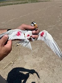
Fig. 2. Interior Least Terns with leg-band attached radio-transmitters with indelible ink color markings for ease of visualization upon re-sightings. Terns were banded at sandbars along the MNRR.
In 2024, biologists captured Least Terns at sandbar nest sites using remotely triggered bow nets and attached standard (non-Motus) VHF radio-transmitters to aluminum leg bands on nine terns and color-marked birds with indelible ink to track movements.
They only recorded on-river detections in 2024, but these included several movements in excess of 20 km, with the longest recorded distance moved of 53.9 km. Most of the long-distance movements occurred after the flood on 20-21 June 2024, so these movements probably represented exploratory flights searching for new nesting habitat.
During the summer of 2025, researchers used the same techniques to capture and tag terns with radio-transmitters. In 2025, they attached six standard VHF radio-transmitters to terns. David Swanson, professor of biology at USD explains, “We followed these terns both by hand at on-river and off-river sites during surveys periods, and we also employed automated receivers at Rose Lake to continuously monitor transmitters (samples collected every 10 min) at this site. Receiver batteries lasted for approximately 18-h periods, and we typically replaced them every 2-3 days, so we did not continuously monitor terns at this site, but we did sample intensively. We tracked terns by hand or by automated telemetry nearly every day until mid-August.”
In July of 2025, biologists also attached Cellular Tracking Technologies (CTT) Motus PowerTags (0.9 g, < 3% of tern body mass) to six least terns. These CTT tags are capable of being detected by automated Motus system recording stations. The only Motus station currently operational in the area is one at Ponca State Park in Nebraska.
According to Swanson, “we recorded several terns at on-river sites by both VHF and CTT tags, but birds stayed mostly near the nesting sandbars in 2025, with the longest distances being only 7.6 km from the nesting sandbars. Both of these terns were birds whose nest had failed. The markedly lower on-river distance moved in 2025 relative to 2024 likely resulted from the absence of a flood during the 2025 breeding season. Nests were not inundated in 2025, obviating the need for long-distance on-river movements to search for new nesting locations.”
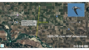
Fig. 3. Standard non-Motus VHF radio-telemetry detections of Least Terns at off-river wetland sites in the summer of 2025. We detected one least tern that repeatedly visited Rose Lake, and off-river pothole lake located approximately 9 km from the nesting colony where we attached the transmitter.
One Least Tern was detected on four separate occasions at Rose Lake. This tern was captured and tagged from a sandbar nesting colony slightly east of the mouth of the Vermillion River, so the distance from this colony to Rose Lake was approximately 9 km to the north (Fig. 3). In addition to several detections of terns from the Ponca State Park Motus stations, five of the six CTT-tagged terns were also detected during migration at other Motus stations (Fig. 4).
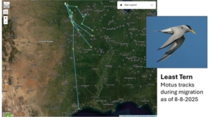
Fig. 4. Detections of Least Terns with CTT Motus Powertags by Motus stations in the summer of 2025. For these five birds, the last detections occurred from 30 July-8 August, with no subsequent detections.
The last detections of these birds ranged from 30 July to 8 August and most terns followed the Missouri River, at least initially, but then left the Missouri River system. One bird appeared to reach the Gulf Coast wintering grounds, but signals from other birds were lost in Missouri. Researchers were not sure why signals were lost, but lost signals could be due to avoidance of Motus stations (about a 15 km maximum radius), shedding of the transmitter away from a Motus station, or mortality away from a Motus station.
Conclusions
From these data, researchers concluded that Least Terns regularly use off-river wetland habitats for foraging up to about 22 km from the river, especially outside of the hatchling period in July. In addition, the appearance of Least Terns at flooded field sites within days of this habitat becoming available indicates that terns will opportunistically use newly available off-river wetland habitat for foraging. This rapid use of newly available habitat suggests that terns regular engage in exploratory surveys for foraging habitat away from the river. Moreover, at least some terns regularly visit off-river sites that are several km distant from the nesting colony. Finally, Least Tern migration pathways may follow the Missouri River, but in most cases appear to stray from the Missouri River/Mississippi River system before reaching the wintering grounds.
Future Research
FOMNRR funding will contribute to the deployment up to four Motus receiver stations at off-river wetlands along the MNRR in summer of 2026. Swanson explains, “We also hope to develop methods for capturing terns at off-river sites and track them back to sandbar nesting colonies on the river to improve tracking detection rates and better define the regularity and distances of foraging movements. With increased detections, we can develop time and energy budgets to quantify the relative contribution of on- and off-river foraging to chick survival and productivity.” Another useful expansion of this research would be to investigate shallow-water habitat forage fish abundance at on- and off-river sites to better inform biologists’ understanding of the factors driving off-river foraging movements in Least Terns. Finally, assessing the long-term impacts of hydrologic alteration and weather disturbance on habitat availability and population dynamics of Least Terns would assist to better define resilience of the population to disturbance, such as flooding and habitat degradation.
 Mark Mahoney/P&D